UN votes to phase out Mercator in favour of map that shows Africa’s true scale
The UN General Assembly approved a Togo-sponsored resolution calling to phase out the Mercator projection in favour of a map based on the 2018 Equal Earth design. The vote was 164 in favour, one against (the United States) and six abstentions. The resolution is non-binding, but backers expect it to prompt changes in school curricula and digital mapping because of Mercator’s widespread use. Supporters, including the African Union and the #CorrectTheMap campaign, argue the change will correct longstanding visual distortions that have minimized Africa’s scale.
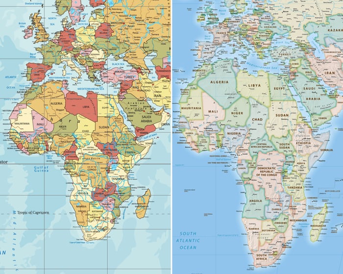
What happened
The UN General Assembly approved a resolution sponsored by Togo that calls for a phased replacement of the traditional Mercator projection with a design based on the 2018 Equal Earth projection. The vote at the UN headquarters in New York recorded 164 countries in favour, a single vote against from the United States — whose representative called the resolution “superfluous” — and six abstentions.
While the assembly’s motion effectively retires the Mercator projection in the text of the resolution, the measure is non-binding and does not legally require countries or institutions to stop using the Mercator map. Supporters nonetheless expect the UN outcome to influence school curricula and everyday technology because Mercator is widely used in education, technology and governance.
Togo led the initiative on behalf of the African Union. Before the vote Robert Dussey, Togo’s foreign affairs minister, framed the debate as scientific rather than political, stating: “This discussion is not a political discussion [but] a scientific discussion, because there is scientific proof so we all have to accept the reality.”
France also signalled support prior to the vote: foreign minister Jean-Noël Barrot said at a Sorbonne speech that France will abandon the Mercator projection in favour of map representations more faithful to actual surface areas, and that France will adopt the Eckert IV projection, which is similar to Equal Earth.
Why this is happening
The Mercator projection was introduced by Gerardus Mercator in 1569 to aid maritime navigation and has remained a global standard in many applications for almost five centuries. Its projection style enlarges high-latitude regions and reduces the apparent size of equatorial regions.
A concrete distortion cited in the source is that the Mercator map makes Africa appear roughly similar in size to Greenland, whereas in reality Africa is 14 times larger than the Danish territory. Advocates of change also point out that numerous large countries could fit within Africa’s landmass: “You could fit the United States, China, India, Japan, Mexico and much of Europe into Africa and still have land to spare.”
Campaigners behind #CorrectTheMap, including a Change.org petition with more than 11,000 signatures and endorsement by the African Union in August 2025, say the Equal Earth design will help reverse perceptions of Africa and decolonise global curricula. Critics of Mercator have for years argued it contributes to what some call “cartographic colonialism.”
Some analysts, such as JJ Enoch of JS Held, have linked the campaign to African nations’ desire for greater influence in global institutions and for more control over how the continent is represented. He argued that adopting an equal-area map would provide a more accurate basis for education and public understanding.
How it will affect things
The resolution itself does not force governments or companies to change their maps, so no immediate, universal switch is mandated. Yet because Mercator is embedded in many educational systems and digital platforms, backers believe the UN statement will lead to updates in curricula and technology over time.
France’s announced adoption of Eckert IV is one concrete example cited by the source of how states might respond. Advocates hope such actions will signal recognition of Africa’s demographic, economic and geopolitical importance and reduce distortions inherited from older cartographic conventions.
The source also notes what remains unspecified: there is no detailed timeline for a global transition, no defined mechanism for implementing the change in international databases and commercial mapping products, and no technical standard for integrating Equal Earth into existing services.
It is therefore unclear how quickly textbooks, educational resources and commercial map providers will change, since decisions in these areas depend on national authorities and private companies that are not bound by the UN resolution.
What comes next
Togo is planning an event in Lomé involving Unesco, the African Union and technology brands such as Google Maps during the first quarter of next year to map out the implementation of the resolution. The stated purpose of that meeting, according to the source, is to outline the steps for putting the resolution into practice.
Further action will require specific agreements about educational changes, coordination with mapping-data providers and adjustments by technology platforms. None of these implementation details are described in the report, so current knowledge is limited to plans for consultation and the political endorsement the resolution has received.
Given Mercator’s near five-century presence, any change of widely used cartographic standards is likely to be gradual and will depend on the choices of states, scientific bodies, education systems and the private sector. The source emphasises that scientific evidence and cartographers’ recommendations are intended to guide subsequent decisions.
Finally, the report includes limited information on the positions of many individual countries that voted in favour and does not elaborate on the reasons for the six abstentions beyond the single explicit dissent from the United States; the pace and scale of any transition therefore remain subject to future negotiations and practical choices.
What we know
- The UN General Assembly backed a Togo-sponsored resolution urging a phased move from the Mercator projection to the 2018 Equal Earth design.
- The vote was 164 in favour, one against (the United States) and six abstentions.
- The resolution is non-binding, but backers expect it to lead to updates in school curricula and digital mapping.
- The Mercator map makes Africa appear similar in size to Greenland, while Africa is actually 14 times larger than the Danish territory.
- Togo plans a Lomé event with Unesco, the African Union and tech brands including Google Maps in the first quarter of next year to map out implementation.
What is being verified
- The newsroom is checking the report that the UN General Assembly backed a Togo-sponsored resolution urging a phased move from the Mercator projection to the 2018 Equal Earth design.
- Reporting from The Guardian World is being compared; a second independent confirmation is not yet available.
View sources1
COMMUNITY
Discussion
Sign in to join the discussion.
No comments yet. Start the discussion.